Showing posts with label map. Show all posts

Friday, December 16, 2011

Maps - Heights of Mountains, Lengths of Rivers

For over 100 years, atlas and map publishers in the United States and Europe published a style of map that was a visualization of the heights and lengths of the world's mountains and rivers. Some of the earliest examples appeared in Europe towards the end of the 18th century. In the United States, the form was popular throughout the 19th century and the early part of the 20th. These maps appeared in atlases, as wall maps, and as pocket maps. One of the most elegant examples was engraved originally on copper by map publisher Henry Tanner in Philadelphia in 1836 and then continued by S. Augustus Mitchell, also of Philadelphia, in lithographic versions into the 1850's.

The Mountains and Rivers maps appeared in several styles and formats. One of the earliest styles was to show just mountains, piled up in a landscape, with a key of mountain heights on the left and right sides of the illustration. Also listed on the side would be the highest flights of the Condor, limits of plants and trees, elevations of lakes, elevation of certain high altitude cites, and climate zones. An early example in the Rumsey collection is Charles Smith's Comparative View of the Heights of the Principal Mountains &c. In The World, published in London in 1816.

Another popular style combined heights of mountains and lengths of rivers in one view. The rivers are stretched out in single lines, with the longest on the left combining with the shortest mountains, while the shortest rivers combine with the highest mountains on the right. The visual result is very compelling. One of the earliest examples was W.R. Gardner's Comparative Heights of the Principal Mountains and Lengths of the Principal Rivers, published by William Darton in London in 1823.


A third variation of the mountain and rivers designs was putting the mountains in the center of the view with the rivers extending downward on each side. One of the earliest examples of this type was published by Henry Tanner in 1836, Heights of the Principal Mountains in the World.

John Dower and Henry Teasdale published another version in London in 1844 titled Principal Mountains and Rivers of the World. It is possible that there was an earlier version of this London map that Tanner copied from - a common practice of American mapmakers in the first half of the 19th century - but Tanner's map is centered on information important to American readers and the Dower/Teasdale map is oriented to England and Europe.

Gray's new map of the World in hemispheres, with comparative views of the heights of the principal mountains and lengths of the principal rivers on the globe, of 1885, provided a simplified view of the mountains and rivers. It appeared in George N. Colby's Atlas of the State of Maine, 1885.

Found Here: http://www.davidrumsey.com/blog/2009/9/5/heights-of-mountains-lengths-of-rivers


earliest known map is a matter of some debate, both because the definition of "map" is not sharp and because some artifacts speculated to be maps might actually be something else. A wall painting, which may depict the ancient Anatolian city of Çatalhöyük (previously known as Catal Huyuk or Çatal Hüyük), has been dated to the late 7th millennium BCE.[1][2] Other known maps of the ancient world include the Minoan "House of the Admiral" wall painting from c. 1600 BCE, showing a seaside community in an oblique perspective and an engraved map of the holy Babylonian city of Nippur, from the Kassite period (14th – 12th centuries BCE).[3] The oldest surviving world maps are the Babylonian world maps from the 9th century BCE.[4] One shows Babylon on the Euphrates, surrounded by a circular landmass showing Assyria, Urartu[5] and several cities, in turn surrounded by a "bitter river" (Oceanus), with seven islands arranged around it.[6] Another depicts Babylon as being further north from the center of the world.[4]

The ancient Greeks and Romans created maps, beginning at latest with Anaximander in the 6th century BC.[7] In the 2nd century AD, Ptolemy produced his treatise on cartography, Geographia.[8] This contained Ptolemy's world map - the world then known to Western society (Ecumene). As early as the 8th century, Arab scholars were translating the works of the Greek geographers into Arabic.[9]

In ancient China, geographical literature spans back to the 5th century BC. The oldest extant Chinese maps come from the State of Qin, dated back to the 4th century BC, during the Warring States Period. In the book of the Xin Yi Xiang Fa Yao, published in 1092 by the Chinese scientist Su Song, a star map on the equidistant cylindrical projection.[10][11] Although this method of charting seems to have existed in China even prior to this publication and scientist, the greatest significance of the star maps by Su Song is that they represent the oldest existent star maps in printed form.

Early forms of cartography of India included the locations of the Pole star and other constellations of use.[12] These charts may have been in use by the beginning of the Common Era for purposes of navigation.[12]Mappa mundi is the general term used to describe Medieval European maps of the world. Approximately 1,100 mappae mundi are known to have survived from the Middle Ages. Of these, some 900 are found illustrating manuscripts and the remainder exist as stand-alone documents.[13]

The Arab geographer Muhammad al-Idrisi produced his medieval atlas Tabula Rogeriana in 1154. He incorporated the knowledge of Africa, the Indian Ocean and the Far East, gathered by Arab merchants and explorers with the information inherited from the classical geographers to create the most accurate map of the world up until his time. It remained the most accurate world map for the next three centuries.[14]

In the Age of Exploration, from the 15th century to the 17th century, European cartographers both copied earlier maps (some of which had been passed down for centuries) and drew their own based on explorers' observations and new surveying techniques. The invention of the magnetic compass, telescope and sextant enabled increasing accuracy. In 1492, Martin Behaim, a German cartographer, made the oldest extant globe of the Earth.[15]

Found Here: http://en.wikipedia.org/wiki/Cartography


Tuesday, September 14, 2010

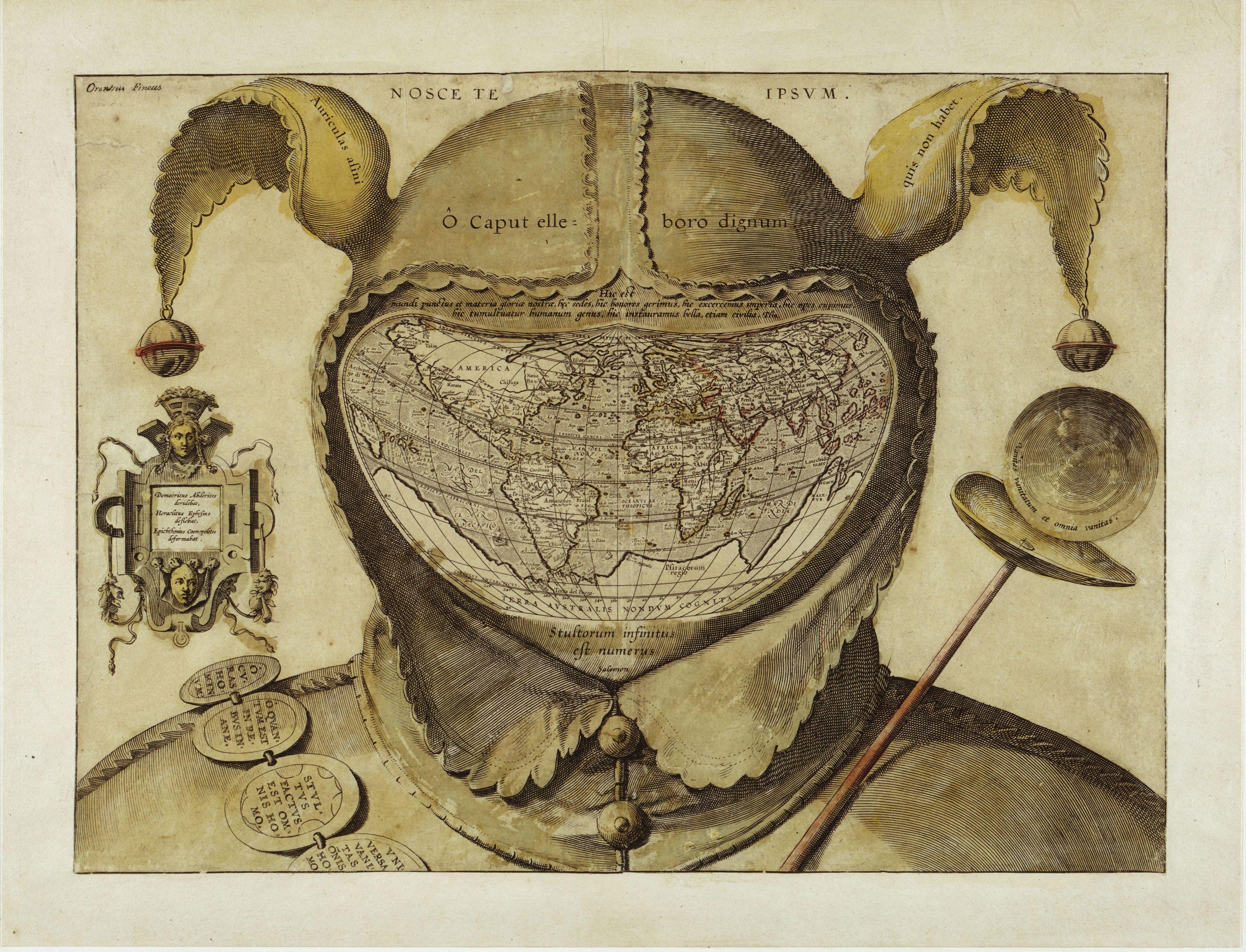
Fool’s Cap Map of the World

Fool’s Cap World Map

This startling and disturbing image is one of the enigmas of cartographic history. The artist, date and place of publication are all unknown, and one can only guess at its purpose. The geography of the map strongly resembles that of the world maps of Ortelius published in the 1580s, giving a tentative date of c. 1590. This is the earliest known use of the world map in a visual joke. Its central visual metaphor is the universality of human folly and various mottoes around the map reinforce that theme. The panel of the left says: “Democritus laughed at it [i.e. the world], Heraclitus wept over it, Epichtonius Cosmopolites portrayed it.” Although Epichtonius Cosmopolites appears to be the author’s or artist’s name, it translates roughly as “Everyman,” leaving the mapmaker’s true identity hidden.

A strong legacy of the theme of the Fool exists in literature and popular art from the fourteenth to seventeenth centuries. The Fool was licensed to break rules, speak painful truths and mock power and pretension, and the grotesque shape he bore was a kind of living punishment. This frame of reference would have been quite familiar to the audience of this engraving in the 1590s. And people would have recognized in this map a radical visual interpretation of the Fool’s role: it is now the whole world that takes on the Fool’s costume, thus forcing the viewer to confront the possibility that the entire created order is irrational, alien and threatening.

Adapted from the book The Image of the World: 20 Centuries of World Maps by Peter Whitfield (Pomegranate Artbooks, 1995)


Found Here: http://myweb.dal.ca/jpekacz/maps.html

This rather sinister image is one of the biggest mysteries in the history of western cartography. Most often referred to simply as the Fool’s Cap Map of the World, it is unknown why, when, where and by whom it was made.

The only thing that can be said about it with some certainty is that it dates from ca. 1580-1590. But sources even differ as to the type of projection used, some referring to it as ptolemaic (i.e. equidistant conic), others claiming it owes more to the techniques of Mercator and/or Ortelius (and being an enthusiast rather than a specialist, I’m not one to call this).

The map shows the world ‘dressed up’ in the traditional garb of a court jester: the double-peaked, bell-tipped cap (1) and the jester’s staff (2). The face is hidden (or replaced) by the map, giving the whole image an ominous, threatening quality that feels anachronistically modern.


The archetype of the Fool, presented here in his incarnation as the court jester, is a first indicator of the map’s deeper meaning. In previous ages, the Fool was a court figure allowed to mock majesty and to speak truth to power. These were rare and useful correctives to the corrupting absolutism of the monarchies of the day. But criticism of this sort was only possible if it was de-fanged by the grotesque appearance of the Fool - preferably a hunchbacked, slightly loopy-headed dwarf, i.e. someone not to be taken too seriously.

All of this would have been common and current knowledge to the people viewing this map, in the late 16th century. The uncomfortable truth told by this map is that the world is a sombre, irrational and dangerous place, and that life on it is nasty, brutish and short. The world is, quite literally, a foolish place.

This is underlined by the mottoes of biblical and classical origin, dotted across the map. The

legend in the left panel reads: “Democritus of Abdera laughed at [the world], Heraclitus of Ephesus wept over it, Epichtonius Cosmopolites portrayed it” (3). Over the cap is the Latin version of the Greek dictum, “Know thyself" (4). Across the cap’s brow, the inscription translates as “O head, worthy of a dose of hellebore” (5).

The Latin quote just above the map is from Pliny the Elder (6): “For in the whole universe the earth is nothing els e and this is the substance of our glory, this is its habitation, here it is that we fill positions of power and covet wealth, and throw mankind into an uproar, and launch wars, even civil ones.”

The reason for so much trouble and strife is explained in the quote below the map, from Ecclesiastes: “The number of fools is infinite” (7). Another quote from that most depressing of Bible books, on the jester’s staff to the right, intones: “Vanity of vanities, all is vanity” (8). Inscribed on the badges adorning the shoulder belt are a few sayings in line with this cheerful message: “Oh, the worries of the world; oh, how much triviality is there in the world” (9), “Everyone is without sense” (10), and “All things are vanity: every man living” (11).

For some researchers, the sum of these messages, as well as their presentation in a cartographic setting, point to a little-known Christian sect called the Family of Love. This clandestine group is said to have numbered the Flemish cartographer Ortelius in its ranks. If this map is anything to go by, the Family of Love must have espoused a rather harsh and pessimistic view of the world, and of humanity’s place in it.

But much remains conjecture, as indicated also by the last piece of this cartographic puzzle - the name written in its top left corner: Orontius Fineus. This name (the Latinised version of the French name Oronce Finé) is associated with a map dated 1531, purportedly showing an ice-free, river-rich Antarctica. Why would the name of this cartographer crop up on a map made decades later? Could he have been the mapmaker (12)? Or is he the one being made fun of?

Many thanks to J.B. Post for alerting me to this map. Many versions to be found online, this high-resolution image found here at Coin des cartes anciennes.

------------------------------------------------------------------------------------------------------------------

(1) the donkey’s ears referring to the supposed stupidity of the ass. Inscribed on them is the quote Auriculas asini quis non habet, meaning “Who doesn't have donkey's ears?" This witticism is ascribed to Lucius Annaeus Cornutus, a Roman stoic philosopher from the 1st century AD.

(2) a parody of the royal staff, a symbol of authority.

(3) Democritus Abderites deridebat, Heraclites Ephesius deflebat, Epichthonius Cosmopolitus deformabat. Epichtonius Cosmopolites seems to refer to the maker of the map, but actually means something like ‘Everyman’.

(4) Nosce te ipsum, in Greek: gnothi seauton. According to Pausanias, an inscription on Apollinic temple at Delphi.

(5) O caput elleboro dignum. Hellebore is a family of mostly poisonous plants, some of which have been used medicinally since Antiquity. It is reputed to induce madness.

(6) Hic est mundi punctus et materia gloriae nostrae, hic sedes, hic honores gerimus, hic exercemus imperia, hic opes cupimus, hic tumultuatur humanum genus, hic instauramus bella, etiam civica. From Book 2, Chapter 72 of the Naturalis Historia (‘Natural History’) by Caius Plinius Secundus.

(7) Stultorum infinitus est numerus (Ecc. 1:15).

(8) Vanitas vanitatum et omnia vanitas (Ecc. 1:2).

(9) O curas hominum, O quantum est in rebus inane, the opening quote of Aulus Persius Flaccus’ Satires.

(10) Stultus factus est omnis homo (Jer. 10:14).

(11) Universa vanitas omnis homo (Psalm 39:6).

(12) Not likely; his dates are 1494-1555. Or could the map predate its estimate by about 30 years?

Found Here: http://bigthink.com/ideas/24015?ref=nf

Wednesday, November 4, 2009

1418 Ming Map - Zhu Di's Map of the World Family

Zhu Di's Map of the World Family

In 1405, Zhu Di sent his favorite Admiral, Zheng He, on a mission to unite the peoples of the "Four Seas"—that is, the World Family. Midway through this enormous undertaking of many overseas voyages, a Ming artist prepared this elegant but somewhat stylized version of the world. It was based on information contained in a variety of field maps and navigational charts. The composite map was intended to represent the final unification of the World Family under the leadership of the Ming Dynasty. It was a visual testimonial about foreign nations (or barbarians) that paid homage to the Son of Heaven in Beijing. It was also a memorial to the role of world commerce in preserving the peace between nations; and it was a graphic representation of the system of transoceanic routes that formed Zheng He's colossal maritime trade network. Zhu Di's dream of a United Family did not last for very long.

Within a few years, Portuguese spies obtained copies of this map. And they used it as the principal tool in world conquest. During that conquest, Europeans claimed they were superior because they had better weapons and maps. They boasted that "the Victor writes the history." And so, the legacy of Zheng He and the heritage of other ancient voyagers faded into the twilight of Western doctrine.

This is a revolutionary map. It will finally force Western scholars to abandon the doctrine of Eurocentrism that has dominated world history for the past 500 years. In the 21st century, the Global Community needs a factual history that reflects the true events of the past. This map can precipitate a paradigm shift in history. Such a paradigm shift is essential in order to dislodge the medieval cultural anchors that are holding us back. Then we can truly build a philosophical foundation of equality for the Whole World Family.

Found Here: http://www.marcopolovoyages.com/Beijing_1481_Presentation/SectionFour.htm

In January 2006, BBC News and The Economist both published news regarding the exhibition of a Chinese sailing map with detailed descriptions of both Native Americans and Native Australians. The map (at right) was dated 1763, and was supposedly a copy of an earlier map made in 1418. Supporters of Gavin Menzies' 1421 theory claim the map as proof that Zheng He sailed to the Americas and Australia. Critics point out that the map, if authentic, is more likely to be based on an eighteenth-century European map.

Detail, Zheng He Map, phonetic transcription of "North America"

According to the map's owner, Liu Gang, a Chinese lawyer and collector, he purchased the map in 2001 for $500 USD from a Shanghai dealer. A number of authorities on Chinese history have questioned the authenticity of the map. Some point to the use of the Mercator-style projection, its accurate reckoning of longitude and its North-based orientation. None of these features was used in the best maps made in either Asia or Europe during this period (for example see the Kangnido map (1410) and the Fra Mauro map (1459)). Also mentioned is the depiction of the erroneous Island of California, a mistake commonly repeated in European maps from the sixteenth to eighteenth centuries. On the map the American continent is labelled phonetically "A-me-ri-ca" (今名北亞墨利加, literally: "Now Name Northern A-me-ri-ca," see detail). This translation was unknown in Ming Dynasty, and is known to be a borrowing from the West, (Amerigo Vespucci).

Geoff Wade of the Asia Research Institute at the National University of Singapore has strongly disputed the authenticity of the map and has suggested that it is either an 18th or 21st-century fake. Wade has pointed out a number of anachronisms that appear in the map and its text annotations. For example, in the text next to Eastern Europe, which has been translated as "People here mostly believe in God and their religion is called 'Jing' (景, referring to Nestorianism)", Wade notes that the Chinese word for the Christian God is given as "Shang-di" (上帝), which is a usage that was first borrowed from Chinese ancient text by Jesuit missionary Matteo Ricci in the 16th century.[49]

In May 2006 the Dominion Post reported that Fiona Petchey, head of the testing unit at Waikato University, which had carbon dated the map, had asked Gavin Menzies to remove claims from his website that the dating proved the map was genuine. The carbon dating indicated with an 80% probability a date for the paper of the map between either 1640–1690 or 1730–1810. However as the ink was not tested, it was impossible to know when it was drawn. Ms Petchey said, "we asked him to remove those, not because we were not happy with the dates, but because we were not overly happy with being associated with his interpretations of those dates."[50]

Found Here: http://en.wikipedia.org/wiki/Zheng_He

Friday, August 29, 2008

Lorenzo Geiger

Hello world! This is the website of the Swiss typographicdesigner Lorenzo Geiger. Have a look at my werkschau which consists in web design and printed matter with a range from corporate identities, record covers, editorial design and knowledge visualization as well as the design of typefaces.

Don’t hesitate to contact me in case of any questions and feel free to sign-up for news. I'm pleased to meet you!

Don't ask people for their number if you know you wont call them anyway. Don't be afraid of the dark. Don't be afraid of dancing spontaneously in environments that are not normally used for dancing. Don't be afraid to dance in clubs where no-one else is dancing. Don't be afraid at all. Don't be ashamed of being proud of your country of origin. Don't be intimidated by bright colors. Don't be politically correct. Don't be sarcastic. Don't be scared of change. Don't be so van about bicycle helmets. Don't bite your nails. Don't buy enormous rounds of drinks for people you don't know at all. Don't buy music through the iTunes music store unless you are sure you will not ever have the urge to play it at party. Don't stop buying CDs. Don't buy new clothes that are exactly the same as the clothes you bought six months ago. Don't buy things on credit except in emergencies. Don't cry for me Argentina. Don't dodge pay the fare. Don't drink as much as last year. Don't drink beer at home. Don't drive an ugly car. Don't drive drunk. Don't talk on the phone when driving. Don't smoke in the car whilst talking on the phone whilst driving. Don't forget that fiction is not real. Don't forget to do what you told everyone you were going to. Don't forget to floss and rinse with a fluoride based mouthwash at least twice a day. Don't generalize. Don't get angry with cyclists. Don't get into fights. Don't get upset that everyone is into apple now and there aren't that many windows users left to argue with. Don't go out with wet hair. Don't ignore important global issues. Don't just take digital photos. Don't lie out in the sun until you get burnt. Don't listen to a word anyone says about your look. Don't listen to In- and Out rankings. Don't do In- and Out rankings. Don't make excuses. Don't miss. Don't over think things. Don't overdo the color coordination thing. Don't let your electronic equipment on standby. Don't pee in public. Don't really like music. Don't ride a bike at night without lights. Don't run over pedestrians. Don't be rude to people on the phone. Don't be rude at all. Don't run with scissors. Don't save. Don't say oh my god. Don't say yes if you mean no. Don't say no if you mean yes. Don't say yes that easy. Don't waste time. Don't forget eating breakfast before you boot your computer. Don't be late. Don't forget to breathe. Don't get addicted to TV series. Don't eat that much pasta. Don't stay up late during the week. Don't smoke as much as last year. Don't smoke the whole cigarette. Don't sneeze in public in Japan. Don't spill other people's drinks. Don't spit on cars. Don't stop exercising once January has passed. Don't stop exploring. Don't stop reading books. Don't stop swimming in the sea through an irrational fear of sharks. Don't tell your partner that dolphins are sharks. Don't mistake dolphins as sharks. Don't waste water. Don't swear in front of children. Don't swear at all. Don't take up expensive hobbies. Don't think about money a lot. Don't talk about dieting at the dinner table. Don't stop till you get enough. Don't think that people do it on their own. Don't say yes that easy. Don't watch too mach TV. Don't wear clothes just once. Don't wear suits with white sneakers unless they are Converse. Don't write songs about your mother. Don't go. Don't go to Lisbon. Don't smoke on the dance floor. Don't underestimate the power of Web 2.0. Don't underestimate at all. Don't pick up the phone in bed. Don't check your mail excessively. Don't drink cheap wine. Don't even buy cheap wine. Don't underestimate the power of love. Don't send newsletters to people who haven't really asked for. Don't believe the hype!

Found Here
: http://ffffound.com/image/a54bf4dfe71a4c4f4c0007474148f923d61f5e6d

and Here: http://lorenzogeiger.ch/